TerraCarta and utility mapping: A 15-year innovative adventure
Welcome to TerraCarta, where innovation and precision go hand in hand in the world of utility mapping. For many years, we have proudly been the specialists in this field, and our passion for progress has led us to new heights. Time and again, we were challenged to solve problems that had no existing solutions. These challenges drove continuous innovations in both hardware and software. Let’s take a look back at some of our most remarkable innovations that have continually refined our services:
TerraCarta Off-Road
It all started with the “ground radar on a sled,” a simple and practical vehicle that allowed us to use our ground-penetrating radar (GPR) in places where a GPR buggy couldn’t reach. But we wanted more, and with the “Survey Trolley” and “Survey Quad,” we expanded our capabilities, enabling us to traverse any terrain, from rough landscapes to railways and even icy surfaces, with precision.
12 years ago, we successfully developed a custom ice thickness meter for a local project. An amphibious vehicle equipped with ground-penetrating radar, allowing us to safely and rapidly map the thickness of ice.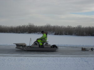
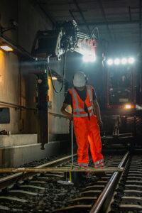
TerraCarta Rail
Next, we introduced the “Alucart,” a covered lightweight trolley powered by electricity, which enabled us to work quickly and efficiently on railway tracks without compromising safety. But it was the “Rail Bus” that stole the show! With our patented TerraCarta technology, this innovative device combined a welding bus, ballast drill with ground-penetrating radar, and other technologies, making it an all-in-one solution for our services in the railway sector.
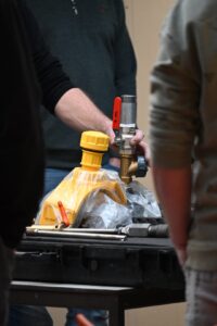
To enhance our commitment to the environment, we automated the sieving of ballast samples collected by the “Rail Bus” using a self-developed ballast sieve. This makes our sieving process faster, safer, and more environmentally friendly. The ballast sample is placed in the machine, and all sieve fractions are automatically sorted, weighed, and stored in the computer.
Always Findable
When it comes to utility mapping, people often think of ground-penetrating radar or utility locators. However, we explored more innovative solutions, such as the advanced “Fish Tape.” This method allows us to map plastic pipelines, equipped with a transmitter at the front. The fish tape can be easily tracked from ground level, providing accurate location data and efficient detection and mapping of plastic pipelines safely.
We remain focused on continuous improvement. We have further developed the existing “Tapping Saddle” to allow tapping of in-service pipelines without leaks. It has been adapted for smaller diameters and various types of pipelines. This enhancement enables us to locate gas service connections quickly and with high precision. To include water pipelines in the same survey, we developed the “Cleansing Bucket – Fish Tape,” enabling us to accurately detect clean water pipelines without contamination.
Moreover, safety and accuracy are paramount in our work. We have added a special insulating coating to our power cable probing sticks and developed special gloves for even safer and more precise work.
Horizontal directional drilling (HDD)
Our excavation methods also evolved steadily. From “Piercing” with a probing stick to a lance propelled by air, then a lance working on water, and finally, the advanced detection device: “Borehole EML.” Each step brought us closer to precision and efficiency. With this last technique, we locate HDD pipes to great depths, and we are the only company capable of achieving such precision and certainty – something we are proud of.
The development of our lance received an extra boost with the unique “Lance Boat,” fully designed in-house, further supporting our work on water.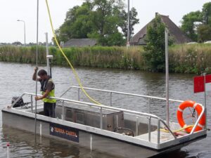
Concrete Scan
New to us was the world of “concrete scanning.” However, we quickly found ourselves undertaking a huge project that required scanning the ceiling day in and day out. Working overhead continuously puts a strain on the survey-specialist. The transition from manual to automated was swiftly realized with the invention of the “Concrete Scan Robot.” Both the hardware and software were entirely designed in-house, giving us control over every detail of this unique creation.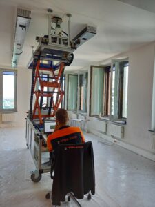
Software
Not only did we focus on hardware development, but we also introduced the “Parser” for data analysis and interpretation, converting GPR data into graphical files. With our leading “GIS tool” and “Microstation Tool,” we can read and interpret GPR data.
Together with the “Geolitix” team, we are working on the development of “UGI,” a system where data, measurement techniques, and processes lead to a consistent result for utility mapping. Our dedicated development team
continues to create handy “software tools” and “macros” to simplify our work and further enhance our services.
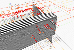
Most Recent Innovations
And as the cherry on top, we proudly present our latest innovation: “3D Ballast Surveys”! Using photogrammetry, we capture images in the ballast, allowing us to assess the structure of the ballast “in-situ” in a 3D environment. A valuable tool to enrich our expertise and share with the world.
At TerraCarta, we are driven by our pursuit of continuous progress, and we are committed to offering our customers the most advanced and reliable services.